 |
 |
 |
 |
Pakenham History : Pakenham-Village of Two Mills - NR Whitwell
A book written by N.R. Whitwell
with permission kindly given by S. Whitwell to publish on
the Pakenham -Village web site.
| Front Cover | Contents | Acknowledgements | Foreword | Introduction | |||||||
| C1 | C2 | C3 | C4 | C5 | C6 | C7 | C8 | C9 | C10 | C11 | C12 |
| App I | App II | App III | Epilogue | ||||||||


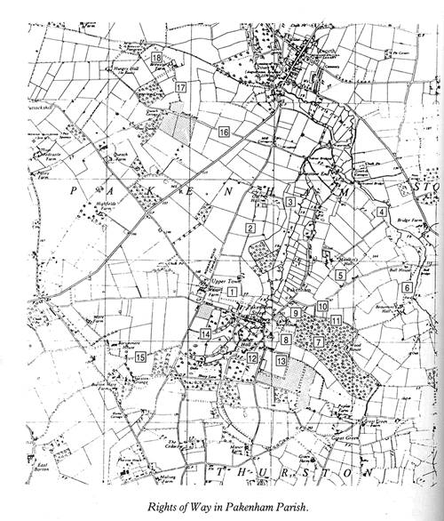
Modern Pakenham is a large parish, having in its parish many scattered houses over the 3,711 acres. This acreage is nearly all good fertile land with woodlands. One of these has become well known for its extensive cover of 124 acres, its famous fox cover and delightful walks eastwards of the Church. The Fen area runs each side of the river and extends beyond the Watermill to Ixworth. In 1844 there were 1,105 inhabitants spread over the parish, in farmhouses and cottages, with hamlets like Upper Town, The Fen Road, Grimstone End forming a reversed letter "L". The short arm of the "L" represents the village Street. The long arm stretches down the Fen Road as far as Ixworth parallel with the river, until the road crosses it at the Watermill in a northerly direction. The western end incorporates quite a little hamlet of new bungalows known as "Mere Close" and "Barton Hamlet", with the historic house of Barton Mere at its extreme.
Following the parish boundary from the Church, going clockwise from Church Hill there used to be a boundary post by the edge of Fiddler's Acre, where the boundary crossed the Park to bisect Nether Hall. Part of this was rated by Thingoe R.D.C. and part by Thedwastre R.D.C. It is alleged to have got its name because the Hall was neither in the hundred of Thingoe nor the hundred of Thedwastre! Today, although the names of the authorities have changed, Nether Hall is still divided for rate purposes. From here the boundary passes through the artificial lake to a spot on the Thurston road leading to the Railway Station near Barton Mere Lane. It follows the lane which it leaves to reach the centre of the Mere, so that parts of the Mere lie in three Parishes: Pakenham, Great Barton and Thurston - thus arranged for the common watering of cattle before the days of the Enclosure Acts. Then, going north westwards, it passes parallel to the Thurston Road to enclose Mere Close and Barton Hamlet (but not the four bungalows standing on the corner of Bury Road), until it reaches the centre of the crossroads at the Bunbury Corner.
The Parish boundary then runs along Brand Road to include Redcastle and Paltry Farms until it reaches the junction of Brand Road and the Queach Road near Livermere. It crosses the fields by Puttockshill on the outer edge of the Pakenham Poors' Firing Land, where the remains of a Roman road is still seen. It proceeds north-eastwards to include the two small farms of Brewster's and Hungry Hall, now incorporated into the Queach Farm. Thence it runs to the Blackbourne River to the south of Ixworth Priory and follows the stream to the centre of Ixworth bridge. This places the Woolpack corner in Pakenham Parish. It then continues along the stream through Micklemere, which is frequently subject to flooding and is the scene of much skating when the Mere freezes. It follows a tributary stream to Bailey Pool bridge, along the northern boundary to the Back Fields, the former Town Estate land. The boundary eventually arrives at Bull Bridge on the Stowlangtoft road and proceeds to Beaumonts Hall and thence to Pakenham Wood, now alas bespoiled, where it bisects the derelict keeper's cottage. It then follows the eastern edge of the wood to join the point by Fiddler's Acre where we started.
So we have come across some extraordinary decisions that have made the Parish boundary what it is. The Nether Hall situation is the first, then to Barton Mere where we might ask why this became so much out on a limb from the rest of the parish. Why does the boundary run behind the houses along the Thurston road - why not in the centre of the road, as is customary? At the point of the Bunbury Corner, four bungalows on the Pakenham side of the road, are excluded from the Parish. At this point, Mere Close and Barton Hamlet are in the postal district of Great Barton. The Woolpack Corner at the Ixworth river bridge, although in the electoral Parish of Pakenham, is in the postal district of Ixworth!
If the Parish of Great Barton succeeds in including the areas around the Bunbury Corner in their Parish, it would seem reasonable. Equally, Ixworth could make the same claim for the parts of the parish they service at the river bridge. Pakenham would, of course, make out their claim on the grounds of history and because of the natural boundaries of river and roads, but these are the problems for the Boundary Commission when they eventually get around to dealing with the parishes. If they ever do.
In the 1981 Census there were about 1,016 inhabitants, with 773 on the Register of Electors, the majority living in or near the Street. This is the focal point of the village and since about 1950, with the coming of main services, the Parish has advanced beyond recognition. When electricity was brought, via overhead cables, it had a marked effect on persuading the District Council to build houses in the village. Over seventy five units of different types - large houses, small houses, maisonettes and bungalows - were built on the Owell Estate alone. Very pleasant bungalows were built by the River Close, and the older ones on Church Hill and at Grimstone End (together with four smaller units opposite the Vicarage) have all been modernised and include a surgery for the local doctors.
Electricity spread down the Fen. Telephone kiosks brought communications nearer, until the next big step was the bringing of a mains supply of wholesome water. This in turn brought about modern sewage disposal and a tap in every house. A new school, playing fields and the general cleaning up process that followed, has made the village an even more pleasant and colourful scene.
On approaching the village from Bury St. Edmunds, one enters the Parish at the Bunbury Arms Corner. There is about a mile of open farm land on both sides until the next crossroads at Upper Town. On the right hand corner stands the old Police House, now in private ownership, whilst on the left hand corner opposite is the Manor, with the hamlet of cottages known as Upper Town. This road goes on past the windmill to Ixworth and is of Roman origin.
Past the crossroads, on the left hand side of the entrance to the village, is a new housing estate, privately built and known as Manor Garth, consisting of some twenty privately owned modern chalet bungalows built in 1965. The felling of some of Pakenham's finest trees to make way for this estate caused some distress in the village. One such magnificent white chestnut was quite the tallest chestnut ever seen. When it was a mass of white bloom it made a most beautiful sight, towering above the rest and, together with the others, formed a beautiful approach avenue to the village. Alas, they were ordered to come down, by the West Suffolk County Council, in order to improve visibility at the entrance of this new estate. In the process, much damage was also done to adjoining trees, necessitating complete removal of further specimens. Although too late, a tree preservation order has been placed upon the remainder.
A little further, and on the opposite side of the road, is Pakenham Lodge. It was the seat of Sir Thomas and Lady Compton-Thornhill, a Conservative Whip in the House of Commons in the 1880's and until recently was occupied by Captain R.L.B. Cunliffe CBE, RN, and the late Mrs. Barbara Cunliffe. A large modern building of white brick and flint with extensive pleasure grounds, it became a special attraction to the public, benefiting Mrs. Cunliffe's favourite charity.
Later Captain "Bob" Cunliffe built himself a bungalow known as The Garden House in the adjoining gardens, where he now resides. It was in the Lodge that Colonel Harry Cooper CMG, JP, with his wife Emily, lived for so many years. He was chairman of the Parish Council from 1922 to 1928 and later Mrs. Emily Cooper gave to the Parish "The Dell" on the opposite side of the road and on the corner of the entrance to the Owell housing estate.
The Dell is a very deep pit surrounded by trees, shrubs and a flint wall which marked the perimeter boundary. The steep slope to the bottom is just carpeted with wild flowers - aconites, anemones, bluebells, primroses and violets - which make it such an attraction. It is quite an adventure playground for the children, who use the steep decline to slide, toboggan and even cycle.
Alongside the Dell is the entrance, off the Street, to the Owell Estate - a large housing undertaking started by Thingoe R.D.C. in 1951. This contains all types of housing units to accommodate all age groups and requirements. There are large and small houses and maisonettes in the form of a circle, with modern bungalows in the centre. It was the surplus from this field after house building requirements had been satisfied that provided local allotments and a four acre playing field.
Opposite the Lodge a new primary school was also built, whose back door conveniently leads on to the playing field where the children play on the swings and roundabouts.
There is a flourishing Football Club with a full size pitch, still leaving room for smaller pitches and other sports. The Bowls Club successfully negotiated with the Parish Council to acquire six redundant weed infested allotments with a water supply laid on, which becomes a hive of bowling activity in the summer months.
Nether Hall is rated by two authorities, as stated earlier, because the parish boundary runs through the middle of the house but the main part of the Hall together with lands comprising the Estate lie in the parish of Thurston. The Manor Farm on this estate is situated halfway between Pakenham and Thurston churches with the Home Farm in Pakenham Village adjoining the Street. Opposite the entrance to the Owell Estate of Council Houses and overlooking The Dell is the Home Farm House enfenced with black iron railings and whose rear entrance is just down the lane, which is known as Home Farm Lane, here Mr. Eric Fitches and son Don lived and farmed.
The farm buildings extended on the left hand side of the lane commencing with a barn which has recently been converted into a large timber built residence. Next comes the Forge where Mr. Davis, having restored The Old Farmhouse, carries on his ornamental iron works nearby. At the end of the range of buildings Mr. Heggarty has converted the modern range of piggeries into a small but successful industry constructing stone fireplaces, and a little lower down has built himself a very modern and pleasing house with magnificent views over the deer meadow and Nether Hall park. All these old farm buildings have been so altered and adapted and the surface of the lane made good that it makes a pleasant village walk from the Street to the Thurston Road, especially during Springtime when the right hand side of the lane is a carpet of snowdrops - hence the old and more popular name of Snowdrop Lane.
On proceeding along the lane the buildings give way to a high embankment surmounted by trees and shrubs which obscures the view to the south east over the pleasant fields and Nether Hall lake. This embankment is a reminder of a violent family quarrel between Sir Walter Green of Nether Hall and Sir Compton-Thornhill of The Lodge. The view from the rear of the lodge across the fields and down on the sloping fields and parkland to Nether Hall was a sheer delight but the quarrel between the two families resulted in Sir Walter, when excavating the lake (Elsie Carter's father supervised this work - see photograph), causing the soil to be carted up to the lane where he built the embankment to prevent the family at the Lodge from ever setting eyes on the Hall again. This bank is known locally as Spiteful Bank.
At the bottom of the hill, having passed the turning into Nether Hall, the road crosses over the river. This is diverted by a weir to surround Bridge House and collect drainage from houses in the Street as it rejoins the main stream. Then it runs parallel to the Street gardens, widening all the time on its way through some wild Fen country and cultivated grasslands, until it arrives at the Watermill, some two miles distant.
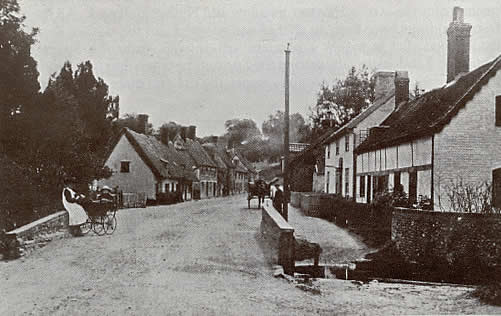
The bridge in 1890, looking East.
On the right, The Fox; on the left, The Bell.
Photo: courtesy of Harry Bridges
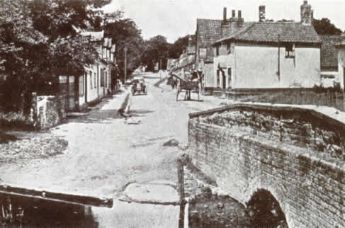
The bridge in the same year, looking West.
The Telegraph public house on the right
Photo: courtesy of Harry Bridges
Once past the narrow river bridge, the road widens into the centre of activities in the village. On the right is The Fox public house, the only one to survive the original five in the Parish. The Bell and The Telegraph, both in the Street, The Royal Oak along Fen Road and The Woolpack by the river have all been converted to private dwellings. Adjoining The Fox was the free reading and coffee room which was supported by Sir E. Walter Green, Bart, who in 1891 sunk the well and presented a pump for public use. This reading room was demolished, together with the adjoining cottages, to enlarge The Fox car park and garage. There were at this time four Working Mens' Reading Rooms. The one in the Street was free and maintained by Sir E. Walter Green MP. Another on Church Hill opened in 1859 and one at Grimstone End was held in a building erected in 1888 which was also used for religious services. The fourth was a Working Mens' Conservative Club.
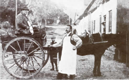
Mr. "Chippy" Melton, village carpenter, in 1890,
and his son, village baker.
The pump mentioned above was restored, the fencing cleaned and painted, and a new plaque with original wording added to commemorate the 90 years of the Parish Council, 1894 - 1984.
The Community Centre on the opposite side of the road to The Fox has a large car park and it was on the far right hand side that the original Village Hall stood for so many years. This was an old First World War army hut which withstood such assorted rigours as an old Pakenham concert party, village whist drives, shows and school dinners. It provided a homely meeting place for all and sundry.
Eventually it almost fell to pieces and was replaced by the present prefabricated Centre, fully modernised with stage, toilets and kitchen. Centrally situated, it is used for important meetings and is the polling station at election times. Here stands the Village Sign.
To commemorate the Queen's Jubilee year of 1977, the village Community Council was asked at a public meeting to arrange celebrations to coincide with the special day when the children had a holiday. The usual mugs were presented to them and the village organised sports events with refreshments, but the Parish Council were anxious to contribute something of more lasting benefit to the village. Suggestions such as tree planting were rejected, as this was a scheme carried out to commemorate the Coronation. Furthermore, had those trees been allowed to grow and flourish the playing fields would be surrounded by beautiful flowering trees by now, but the vandals just broke them down. Later they were replaced under a County Council Tree Planting Scheme, but again they were broken down, so this idea was not acceptable. Restoration of the Village Pump, suitably enfenced with the original iron railings, was also suggested; but the big disappointment was the rejection of a Riverside Walk. We have a beautiful river flowing behind the houses in the Street and winding its way for about a mile through fen and fields to the watermill, bordered with exotic plants and rare birds.
A hidden beauty, but inaccessible because a house owner in the Street would not allow the public to pass through a gateway to the river or use the river bank, nor could the owner of private land behind the Village Hall be persuaded to sell a strip for access. There were other suggestions which for various reasons were not acceptable. And so when the Community Council approached the Parish Council for a contribution towards a public fund for a Village Sign, it felt it could justify such a contribution from the Village Rate, being a feature that might have a lasting benefit. As the largest contributor, the Parish Council were consulted about the design, siting, materials and costs, so it rather became a joint effort in so far as the Community Council paid for the carving and painting from their funds, whilst the Parish Council undertook to erect and construct a seat at the base. It was eventually agreed after numerous controversial suggestions that it should be sited outside the Village Hall, close by the entrance, on the car park land. A design was agreed. A professional wood carver, Mr. Carter, who lived in Swaffham and who had done many of the Norfolk Village signs, was commissioned. So, together with some very good old oak from the Manor barn which had stood in Pakenham for hundreds of years, Mr. Carter started work. Eventually it was ready. A builder in the neighbouring village of Norton undertook to make the circular seat in flints and red bricks with a wooden top, and so on Sunday 4th June, 1978, the unveiling ceremony took place after Church. Miss Elsie Carter, who had been the Village School Head teacher for a very long time, unveiled the sign, remarking "when one gets over eighty years of age one no longer makes a speech". This was followed by the blessing by the Vicar, John Newell, then finally the Chairman of the Parish Council gave a resume and described the design as one that comprised the four main features of the Parish: the river, winding its way between the windmill and the watermill, with the Parish Church of St. Mary surmounted at the top, overlooking the whole Parish from the hill. In describing the river, he pleaded that anyone who wanted to explore the river should certainly go by boat. We were very glad the Suffolk Preservation Society had purchased the watermill, as the village was unique in having two mills in working condition. With our church being a fine example of devotion and craftsmanship of our forefathers, this is a source of pride and inspiration to us all.
After the donors were thanked, all present were asked to look after it and protect it, as it was partly owned by everyone who paid rates. Finally, there was a vote of thanks to Her Majesty for twenty five years of most devoted service to us all. It was a beautiful sunny morning and crowds turned out to see one of the most picturesque signs in Suffolk. It met with general approval. The children mopped up the refreshments that were provided to clear the little balance of cash in hand.
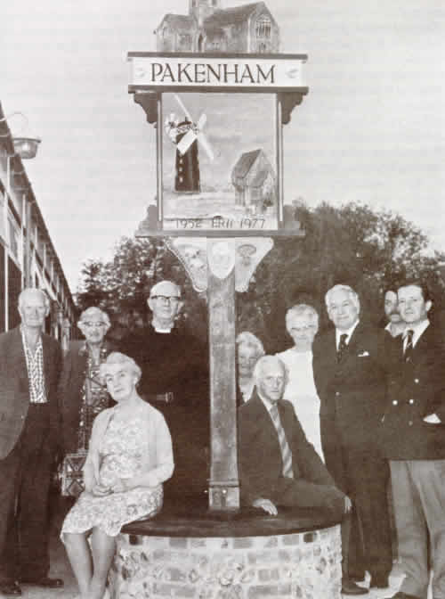
Pakenham Village Sign
Left to right: Jack Smith, Mary Newell, Elsie Carter, Revd. John Newell,
Ida Studd, Arthur King, Iris King, Cllr. Roy Whitwell, Richard
Ashley, Christopher Spicer.
We have already passed one shop, the village stores - a mini supermarket type - just before the river. The village Post Office, Newsagent and Stores gives the village a second shop, next door to a garage and service station in the Fen Road and these supply the needs of the inhabitants.
Incidentally, thinking back to about 1950, it was the Post Office Stores where the village first experienced the self-service idea when Mrs. Melton displayed a rack of daily newspapers and a coin box, inviting customers to serve themselves.
At the end of the Street there is a fork in the road. The left hand passes the Post Office and garage, with Newe House on its right and goes onwards to the Fen, Grimstone End and Ixworth. Or, turning up Bull Hill to Stowlangtoft, it leaves Maulkins Hall to the left and Beaumonts Hall to the right.
It was at the turning to Stowlangtoft that the old village refuse pits were situated and if one digs down deep enough the bones of a large herd of cattle from the Manor Farm will be uncovered. These cattle, having contracted some fatal contagious disease, were slaughtered on the farm and conveyed by horses and sledges from Upper Town, the length of the Street, round Fen Road until they reached the pits on Bull Corner where they were capsized off the sledges, covered with lime and disposed of. These journeys took several days and was a most distasteful farm job.
Back to the end of the village Street. The right hand fork leads up Church Hill passing firstly, on the right hand side, the Old Village School discerned by the broken-flint walls and front door porch. The date of the building (1842) is clearly embedded in the lintel of what is now a private house.
When this National School was built, there was also a house for the master adjoining. There were one hundred and twenty children attending and subsequently it was enlarged to accommodate seventy additional scholars. This is in marked contrast to the present time, 1980, when our new school is threatened with closure because less than thirty children attend and this includes the children from Stowlangtoft.
Next to the old school is the row of Charity Cottages. These cottages were built in 1647 and were previously known as The Workhouse, before that The Guildhall. They had been modernised and form small units of accommodation for elderly inhabitants. There is a doctor's surgery at the end, and after modernisation by Thingoe R.D.C. in 1960 they were renamed Church Green.
On the opposite side of the road and behind a tall box hedge is the Old Vicarage with its famous window, beautiful old trees and a garden path leading into the Churchyard and thence up hill to the Church. A little further along the road are the eight Church Council houses, which concludes the Parish boundary in that direction.